Tunis Mills Road over Leeds Creek Bridge Replacement
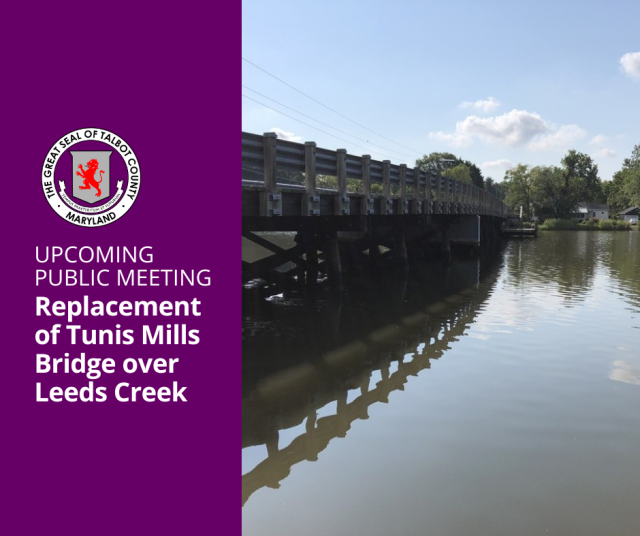
Summary

Project Investment Up to $6 Million ($1.5M local funds, $4.5M federal funds)
Current Status Design Phase (90%-95% complete)
Next Steps Right-of-way acquisition, environmental permits, and stormwater management design
Project Schedule Anticipate advertisement for construction in late winter or early spring of 2024 (depending on right-of-way acquisition and environmental permits)
Construction Duration Anticipated to be approximately one year (road closure)
Project Manager / Contact Mike Mertaugh, Assistant County Engineer
Consultants / Partners

Wallace Montgomery

GPI

Location

The project is located at the bridge that spans across Leeds Creek, located near 26209 Tunis Mills Rd., Easton, MD, the current location of the public landing.

Project Details

Background Discussions on the project started nearly 20 years ago when the County did a preliminary engineering report to look at replacing the bridge. In 2007, the previous County Council appropriated $1.8 million to the replacement project through Bill No. 1082. The design phase began, but was put on hold until 2022. 
Details

Bridge Integrity

  • General condition ratings are used to describe an existing bridge or culvert compared with its condition if it were new. The ratings are based on materials, physical condition of the deck, the superstructure (structures immediately beneath the driving surface), and the substructures (foundation and support posts and piers). General condition ratings range from 0 (failed condition) to 9 (excellent). The current Leeds Creek Bridge has a general condition rating of structurally deficient.
  • Sufficiency ratings were developed by the Federal Highway Administration to serve as a prioritization tool to allocate funds. The rating varies from 0% (poor) to 100% (very good). The formula considers structural adequacy, whether the bridge is functionally obsolete, and level of service provided to the public. When the bridge replacement project began, the bridge was borderline structurally deficient. However, in the last bridge inspection, the bridge has been determined to be structurally deficient that has resulted in a weight limit for the bridge.

Key Design Features

  • In early discussion of design, Council was presented with various options for the replacement of the bridge design, which included proposed bridge height, clearance, construction materials to be used, anticipated costs of same, and add-ons. Council reiterated some of the comments made at the public hearing held on February 24, 2009. Council comment ensued and straw polls were taken on design elements. View summary here: 
  • In that meeting, the Council approved the design of the bridge, which resulted in the following bridge attributes:
    • Length
      • Existing: Approximately 345 feet
      • Proposed: 357 feet
    • Width
      • Existing: 22 feet
      • Proposed: 25.7 feet (expanded shoulder area on platform side)
    • Underclearance
      • Existing: Approximately 7.5 feet from mean high water (normal high tide)
      • Proposed: Approximately 9.5 feet from mean high water (normal high tide), height of bridge was raised 2-feet with proposed design
    • Substructure (below deck)
      • Existing: Timber piles and pier caps
      • Proposed: Steel piles and concrete pier caps (federal requirement)
    • Superstructure (deck)
      • Existing: Timber framing and timber deck boards
      • Proposed:  Laminated wood deck and asphalt wearing surface
    • Railing
      • Existing: Metal 'W' railing with timber posts
      • Proposed: Timber railing on timber posts
    • Water Access Platform
      • Existing: Approximately 20 feet by 10 feet
      • Proposed: Approximately 20 feet by 10 feet
    • Posted Speed Limit
      • Existing: 15 miles per hour
      • Proposed: 15 miles per hour
    • Boat Ramp
      • Existing: Asphalt and gravel surface
      • Proposed: Asphalt and concrete


Additional Resources

Meetings

February 24, 2009 Council Meeting Minutes

March 10, 2009 Council Meeting Minutes

September 26, 2023 Work Session

 Images
Car Clearance
Side Angle shows car clearance, and includes expanded shoulder area on platform side. Talbot County Department of Public Works, 2023.

Side Angle of Leeds Creek Bridge Design
Additional Side Angle shows bridge clearance over Leeds Creek. The unclearance from center span will be approximately 9.5 feet from mean high water (normal high tide). Talbot County Department of Public Works, 2023.

Aerial View of Leeds Creek Bridge Design
Aerial View shows how the proposd length will extend on either side of the current crossing. Replacement bridge will be placed in same footprint as current bridge, but wil require right-of-way acquisition to adjust for longer and wider bridge. Talbot County Department of Public Works, 2023.
BrucevilleBridge01870
Image of Bruceville Bridge, another bridge in the county that represents similar design style of proposed replacement bridge. Talbot County Department of Public Works, 2023.


Additional Resources

Bill No. 1082 (Enacted August 14, 2007)- Authorizes improvement to the Tunis Mills Bridge. Scope of work included design, construction of bridge replacement, and other improvements as needed in the amount of $1,800,000.

February 24, 2009 Council Meeting Minutes - Public hearing for proposed bridge replacement designs.

March 10, 2009 Council Meeting Minutes - Council voted to approve design of the bridge as incorporated in the motion.

Tunis Mills Bridge Replacement Fact Sheet (2023) - Project Fact Sheet provided during public informational meeting on July 26, 2023

Work Session Presentation - Presentation that was provided during work session with Council on September 26, 2023


Page last modified Friday, January 26, 2024 10:33:42 AM